advertisement
14 February 2022
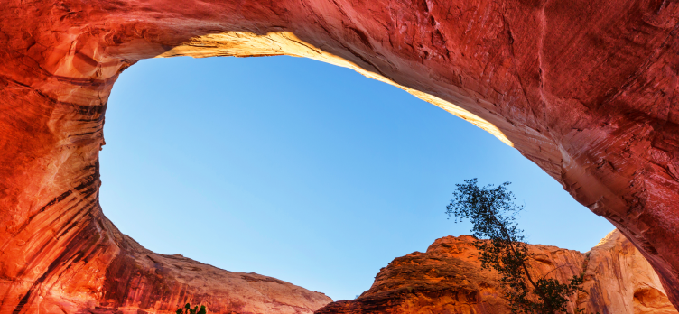
In the Vermilion Cliffs in Arizona/Utah, you can hike The Wave’s sandstone formation, a gorgeous red sandstone formation. Paria Canyon/Vermilion Cliffs Wilderness lies on the Utah-Arizona border, halfway between Page, Arizona, and Kanab, Utah. Because of the site’s popularity, the Bureau of Land Management limits foot traffic into the Canyon to preserve its integrity and beauty. It was previously restricted to only 20 hikers a day, but in February 2021, the daily hiking quota increased to 64 hikers per day.
Even with the increased quota, it’s still hard to get a permit for the site simply because so many people wish to experience The Wave. For example, only 7,300 people received access in 2018 out of 168,317 applicants.
advertisement
In Vermilion Cliffs National Monument, the Wave is most commonly accessed from the Wire Pass Trailhead and is located in the North Coyote Buttes permit area. During the moderate 6-mile hike, you will mostly encounter red rock and sand. Due to the harsh desert heat, bringing a map and basic navigation skills is advisable, particularly if you plan to hike cross-country.
Permits for hiking The Wave in Arizona can be obtained in two ways. The advanced online lottery is a good chance to try your luck if you can plan. If your trip is last minute or unsuccessful in the Wave lottery, you can also enter the in-person lottery at the Kanab Visitors Center.
Permits for the Wave are only issued to 64 people per day. The online lottery system award permits 48 people (or 12 groups, whichever comes first). Permits are awarded to the remaining 16 people (or four groups, whichever comes first) via a walk-in lottery. Applicants pay $9 for the online lottery, which is non-refundable, even if they don’t win.
In terms of permit competition, the months of March through November are the most competitive, while December through February has the best chances. But keep in mind that, while the chances of getting a permit are higher in winter, there is also an increased chance of bad weather and impassable roads.
It is very competitive to obtain a permit for The Wave, whether through advanced online applications or walk-ins, and only a tiny percentage of applicants can hike It each year. So what if you’re not in the lucky group?
You can apply for a permit for Coyote Buttes South. Several hiking trails near the Paria Canyon-Vermilion Cliffs Wilderness are geologically similar to the famous “wave,” complete with sandstone bluffs and wave formations.
Lucky enough to get a permit? Nice. To make the most of it, start with a nice loop hike that starts and ends at The Wave. It takes about 90-minutes to hike from the Wire Pass trailhead to The Wave.
advertisement
To see the dinosaur tracks, return to the wash by retracing your steps back down the dune. Upon reaching the foot of the dunes, turn west, cross the wash, and ascend to the dinosaur tracks. They are in red stone near the wall. The tracks are hand-sized and three-toed. Usually, they are arranged in a line in a small cluster.
Continue south for .3 miles until you reach an open area. About 50 yards to the west is a small, brown, and yellow striped area with some rocks that look like tic-tac-toe boards laying on the stripes. Michael Fatali, a gifted photographer from Arizona, named the area “The Boneyard.” These loose rocks are called lace or box rocks. Don’t move them as they are fragile.
Head down the sandy wash that runs southeast after leaving The Boneyard. In .2 miles, turn more south into Sand Cove Wash. Hike up about 100 yards to the teepees to your east (left). Here you’ll find Sand Cove — an area with beautiful sandstone curves.
You can hike east-northeast from Sand Cove and climb up the cliff until you reach a flat area just before you reach a much steeper ridge. The Second Wave is located at the foot of this cliff. This location is excellent for late afternoon photographs.
Once you’re ready to return to the Wire Pass parking lot, head north, passing back through The Wave, the hike back should provide many more photo opportunities. Once you leave The Wave, head down the dune, cross the wash, and head north to retrace your steps back to your car. Be advised that you should leave The Second Wave well before sunset if you do not have good navigation skills or if you do not have a GPS.
The Wave is an unbelievable adventure! It’s an exclusive and private site, making it even better. Permits are hard to obtain, but the lack of crowds makes it even better. In silence, you can marvel at the wonder of Mother Nature.
advertisement
Arizona is famous for its desert landscapes, dramatic sunsets, and historic landmarks. But across the state, another form of art is quietly transforming walls, alleyways, and entire neighborhoods. Street art has become one of the most vibrant and accessible forms of creative expression in Arizona, turning ordinary buildings into outdoor galleries. From massive murals in downtown Phoenix to colorful installations in Tucson and unexpected pieces tucked into smaller towns, Arizona’s street art scene reflects the culture, history, and creativity of the communities that create it. advertisement Phoenix: A Growing Urban Canvas Phoenix has become the center of Arizona’s street art
Long before astronauts set foot on the lunar surface, scientists in Arizona were already studying it in remarkable detail. By the time President John F. Kennedy announced in 1961 that the United States would land a man on the moon before the end of the decade, researchers at the University of Arizona had already begun mapping the moon’s surface. Their work would prove critical to the success of NASA’s robotic missions and the historic Apollo landings. At the center of this effort was Gerard P. Kuiper, widely known as the father of modern planetary science. advertisement The Birth of Lunar
Arizona is a paradise for bird watchers, offering a diverse range of habitats that support both native species and migratory birds. From its desert landscapes to its high-altitude mountains, Arizona is home to an astonishing array of bird species. However, some birds in the state are considered rare, either due to their limited range, dwindling populations, or specific habitat preferences. In this article, we’ll explore some of the rarest birds in Arizona and what makes them so special. advertisement 1. California Condor (Gymnogyps californianus) Status: Critically Endangered The California Condor is arguably one of the most iconic rare birds in
Arizona summers can make outdoor play feel impossible, especially in the middle of the day. The good news is there are plenty of affordable, family-friendly options that keep kids cool, active, and entertained without turning it into a big-ticket outing. Below are budget-friendly ideas across the Valley, including museums, indoor play spots with strong reviews, and free or low-cost options for early mornings and evenings. advertisement 1) Affordable Indoor Museums (Air-Conditioned and Worth It) Idea Museum (Mesa) If you have younger kids who love hands-on play, art, and creative exploration, the Idea Museum is a solid summer option. It is