advertisement
24 March 2025
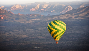
The Bureau of Land Management has announced a $2.4 million investment from the Investing in America agenda. This initiative will support a cultural landscape study and predictive model for public lands in California and Arizona. The study aims to assess the impact of renewable energy development on Tribal ancestral lands as well as other significant landscapes in the Colorado River Basin, helping to improve the responsible siting and processing of renewable energy right-of-way applications.
advertisement
As the world shifts toward cleaner, more sustainable energy sources, the United States has emerged at the forefront of renewable energy projects. Under the Biden-Harris administration’s Investing in America agenda, the BLM has spearheaded efforts to approve renewable energy projects across public lands. The BLM has made significant strides, surpassing the 25-gigawatt clean energy target for 2025, with solar, geothermal, and wind energy projects now providing power to millions of homes nationwide. But as solar farms rise on the horizon and wind turbines turn in the breeze, questions about the impact on the environment and communities linger.
In California and Arizona, many renewable energy projects sit on or near Tribal ancestral lands—lands sacred to Indigenous people who have lived there for millennia. The impact of these projects is not merely physical but cultural, as these lands hold deep spiritual significance for the Tribes that call them home.
To address these concerns, the BLM announced a partnership with the U.S. Department of Energy’s Argonne National Laboratory, with an investment of $2.4 million, to create a comprehensive cultural landscape study and predictive model for renewable energy development in the region. The goal? To better understand the cultural and environmental impacts of energy development on Tribal lands and other significant landscapes, guiding the responsible placement of energy projects.
“It is important to understand the cultural values of the lands in our care, so we can guide clean energy projects to appropriate places,” said BLM Director Tracy Stone-Manning. ”The BLM looks forward to working with Tribal Nations and other partners as we conduct this assessment that will help us ensure that clean energy projects are developed responsibly.”
The study will examine the Colorado River Basin, a region of profound importance stretching across both states and encompassing vast areas of public land. The results will help ensure that future clean energy projects are carefully sited, balancing environmental sustainability and respect for Indigenous heritage.
advertisement
At the heart of the study is the integration of Indigenous Knowledge. The BLM recognizes that Indigenous communities have been stewards of the land for generations, and their cultural insights are invaluable in understanding the true impact of land use changes. The study will incorporate an extensive inventory of archaeological, ethnographic, and ethnobotanical data—much of which comes from Tribal communities. In addition, visual and viewshed studies will provide a way to analyze how new developments could affect the sacred landscapes viewed by Tribal nations.
The data collected will not only help guide future development. They will also allow for a deeper understanding of the land’s cultural significance, offering a powerful tool for negotiation and advocacy for Tribal nations as they work with developers.
As part of the larger Investing in America agenda, BLM has made significant progress toward transitioning the country to a 100-percent clean electricity grid by 2035. Additionally Renewable energy projects on public lands now provide enough power to serve over 12 million homes, making a crucial contribution to the nation’s energy future.
The partnership with Argonne National Laboratory—already successful in providing cultural landscape assessments in Colorado, New Mexico, and Utah—brings a wealth of expertise in environmental science, technology, and data analysis.
As the study continues, one thing remains clear: the United States’s energy future will only be truly sustainable if it is built on the foundation of respect for the land as well as the people who have called it home for thousands of years.
advertisement
Nestled into a towering limestone cliff in central Arizona, Montezuma Castle National Monument is one of the best-preserved ancient dwellings in North America. Despite its name, the site has nothing to do with the Aztec ruler Montezuma. Instead, it stands as a remarkable testament to the ingenuity and resilience of the Indigenous people who lived in the Verde Valley centuries before European explorers arrived. Today, Montezuma Castle National Monument offers visitors a fascinating glimpse into Arizona’s rich cultural history and remains one of the state’s most popular historic attractions. advertisement What Is Montezuma Castle? Montezuma Castle is a five-story cliff
Tucked away in the remote landscapes of northern Arizona, Paria Canyon-Vermilion Cliffs Wilderness is one of the most spectacular and least crowded outdoor destinations in the Southwest. Known for its towering sandstone walls, colorful rock formations, winding slot canyons, and breathtaking desert scenery, this wilderness area offers an unforgettable experience for hikers, backpackers, photographers, and nature lovers. If you are looking for an adventure beyond Arizona’s more famous parks and attractions, Paria Canyon-Vermilion Cliffs Wilderness deserves a spot on your travel list. advertisement Where Is Paria Canyon-Vermilion Cliffs Wilderness? The wilderness area spans portions of northern Arizona and southern Utah,
When most people think of Flagstaff, Arizona, they picture cool mountain air, pine forests, and easy access to some of the Southwest’s most beautiful landscapes. What many do not realize is that this mountain town has also played a remarkable role in humanity’s exploration of space. For more than a century, Flagstaff has been at the forefront of astronomy and planetary science. From the discovery of Pluto to helping astronauts prepare for the Moon, the city has earned a reputation as one of the most important locations in the history of space study. advertisement The Birth of Astronomy in Flagstaff
Today, Mill Avenue is known as the heart of Downtown Tempe. Lined with restaurants, shops, nightlife, and entertainment venues, it attracts students, residents, and visitors from across Arizona. But long before it became a popular destination, Mill Avenue played a central role in the founding and growth of Tempe itself. The story of Mill Avenue is closely tied to agriculture, transportation, Arizona State University, and the evolution of Tempe from a small farming community into one of Arizona’s most vibrant cities. advertisement The Early Days: Hayden’s Ferry and Agriculture The history of Mill Avenue begins in the late 1800s. Following